





Drone video captured moment Himalayan glacier collapsed before deadly Nepal-Tibet floods

5 min readUpdated: Aug 28, 2026 11:08 PM IST
A massive glacier collapse high in the Himalayas has been captured on drone video, offering new clues to what triggered the devastating floods that swept through Nepal and Tibet this week.
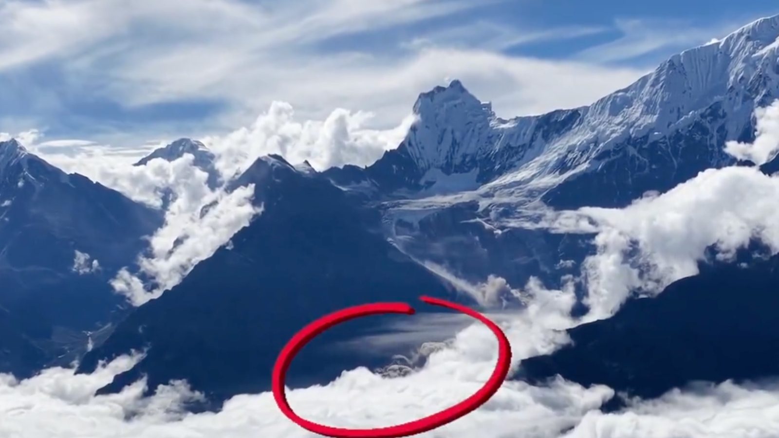
The footage, authenticated by BBC Verify, shows a landslide near the Langtang Lirung peak, more than 7,200 metres above sea level, with huge plumes of dust rising from the snow-covered mountains. The location of the videos matches the direction of the floodwater that later surged down the Trishuli river system, according to BBC Verify.
ABC News reported that a Chinese photographer’s camera drone accidentally captured the aftermath of the initial glacier collapse.
Someone captured the moments just after a huge section of the glacier crack off
You can see it ripping down into the valley pic.twitter.com/TIYDkMlj01
— Richard Burton (@Ricburton) August 28, 2026
The footage provides striking visual evidence of the collapse as scientists and authorities piece together how falling ice and rock may have temporarily blocked a river before unleashing the deadly deluge downstream.
How did the glacier collapse trigger the floods?
Scientists are still piecing together the sequence using satellite imagery, seismic data and ground-level information.
One emerging explanation is that a large mass of ice and rock fell into the Lhende River and temporarily blocked its flow, creating a natural landslide dam. When that barrier gave way, water and debris may have surged downstream into the Bhotekoshi and Trishuli river systems.
China’s Foreign Ministry spokesperson Lin Jian said preliminary assessments by experts and official institutions in China and Nepal indicated that the disaster “may have been triggered by the collapse of a high-altitude glacier in Nepal”, news agency PTI reported.
Story continues below this ad
Nepal’s National Disaster Risk Reduction and Management Authority has also identified an ice-and-rock avalanche as the leading explanation, while an assessment by the US Geological Survey pointed to a glacier collapse and debris flow, according to the material supplied.
The US Geological Survey reported a magnitude 5.2 glacier collapse, based on seismic data and satellite imagery. News agency Associated Press reported that scientists were continuing to examine the precise chain of events.
The initial theories had included a glacial lake outburst flood, or GLOF, and an avalanche. The evidence now emerging is increasingly focused on a glacier collapse followed by a temporary river blockage and sudden release of water and debris.
Death toll rises as rescue teams search for missing
The floods devastated communities and infrastructure on both sides of the Nepal-China border. Nepal’s disaster authorities have reported hundreds of deaths and hundreds of people missing, while China has reported five deaths and hundreds of people missing in Tibet. The figures have changed rapidly as rescue teams reach areas that were previously cut off.
Story continues below this ad
The floods destroyed roads, bridges and power infrastructure along a route connecting Kathmandu with Lhasa in Tibet. The corridor is also used by trekkers and pilgrims travelling towards the region.
More than 3,700 people have been rescued in Nepal, according to the latest Associated Press update in the supplied material, while thousands of security personnel have been deployed in the search-and-rescue operation.
New lake creates another flood threat
The disaster has also created a fresh danger. A lake formed after debris blocked a river upstream had accumulated millions of cubic metres of water. News agency Reuters reported that the volume had risen above 2.5 million cubic metres before the lake overflowed into the Bhotekoshi River.
The development triggered warnings for people living downstream and briefly disrupted rescue operations. Nepal halted rescue operations for about 90 minutes before restarting them, according to Reuters. Chinese rescue personnel and vehicles were also moved to safer ground before operations resumed after authorities assessed the risk as manageable.
Story continues below this ad
The new threat has complicated an already difficult operation in areas where roads and bridges have been destroyed, and some communities remain accessible only by helicopter.
Around 320 Indians remain uncontactable
The disaster has a significant Indian dimension because the affected region is used by tourists and pilgrims travelling towards Tibet, including those visiting Mount Kailash and Lake Mansarovar.
The External Affairs Ministry said around 320 Indian nationals remained uncontactable. It said 96 Indians stranded on the Chinese side had crossed into Nepal by land and that efforts were continuing to evacuate those affected.
India is also sending another flight carrying relief supplies and a tunnel rescue team, while a prefabricated bridge has been sent to Nepal to help restore connectivity in the flood-hit areas.
Story continues below this ad
China has also deployed rescue teams to the worst-hit areas around Gyirong. Chinese state media said more than 1,000 people, including hundreds of tourists, had been evacuated from the county.
(With inputs from agencies)
Stay updated with the latest – Click here to follow us on Instagram
