

Powerful earthquakes in Indonesia, Colombia, Venezuela: Is ‘Ring of Fire’ waking up?


A powerful 7.7-magnitude earthquake off Indonesia’s Flores region on Saturday has brought fresh attention to the Pacific “Ring of Fire”, the vast zone around the Pacific Ocean where major tectonic plates meet, and earthquakes and volcanic eruptions are particularly common.
The powerful quake struck at 5:58 am local time at a depth of about 10 kilometres, with its epicentre about 68 kilometres (42 miles) north-northwest of Ende in East Nusa Tenggara, according to the US Geological Survey (USGS). Indonesia’s disaster management agency said at least 47 people were killed, while dozens more were injured.
The earthquake triggered a tsunami warning along parts of Indonesia’s eastern coast. The warning was later lifted after monitoring showed no significant continuing threat, although the Indonesian meteorological agency recorded small tsunami waves in several coastal areas.
.
World · Indonesia · By the numbers
Indonesia earthquake: the key numbers
A magnitude 7.7 quake struck off the Flores region of eastern Indonesia early on Saturday, August 15, 2026.
7.7
Magnitude
off the coast of Flores
47+
Killed
provisional — toll expected to rise
The quake
10 km
Depth (shallow)
5:58 am
Local time it struck
68 km
NNW of Ende (epicentre)
235+
Aftershocks (largest M6.2)
1.61 m
Highest tsunami wave (Riung)
6.9
Separate N. Sumatra quake — too deep (172 km) for major damage
The human toll & damage
50+
Taken to hospital
~2,000
Villagers displaced
6
Regencies hit by landslides
157
Houses flattened
~200
More houses damaged
100+
Public facilities destroyed
The response
3
Helicopters deployed
1
Rescue vessel deployed
~700 km
Trans-Flores highway blocked by landslides
In context — past Indonesian disasters
1992~2,500killed by a quake and tsunami on Flores
20184,400+killed by a magnitude 7.5 quake and tsunami (Sulawesi)
2004230,000killed across a dozen countries by the M9.1 Sumatra tsunami
Figures are provisional and, for casualties, expected to change as search and rescue continues.
Sources: Associated Press · US Geological Survey · Indonesia’s National Disaster Management Agency (BNPB) and meteorological agency, as of Aug 15, 2026.
.
According to The Associated Press, the largest recorded wave reached 1.61 metres (5.3 feet) in Riung, while a wave of 0.94 metres was observed in Maurole in Ende Regency. The AP also reported that the earthquake was followed by at least 235 aftershocks, the largest measuring magnitude 6.2.
The disaster has also complicated rescue operations. Reuters reported that landslides and communication disruptions were hampering access to areas around Nagekeo and other parts of Flores. More than 150 homes were destroyed or flattened, while schools, health facilities and other public buildings were also damaged.
The latest earthquake is particularly significant because of where it occurred — and because Flores has experienced a deadly tsunami before.
Why does Indonesia get so many earthquakes?
Indonesia lies along the Pacific Ring of Fire, a horseshoe-shaped zone surrounding much of the Pacific Ocean where several tectonic plates meet.
Story continues below this ad
The USGS describes the circum-Pacific Ring of Fire as the world’s most seismically and volcanically active zone. It exists largely because the Pacific Plate meets and interacts with several surrounding plates.
About 81 per cent of the world’s largest earthquakes occur along the circum-Pacific seismic belt, according to the USGS. Many are generated at subduction zones, where one tectonic plate sinks beneath another.
This helps explain why countries stretching from South America to North America and across the western Pacific repeatedly experience powerful earthquakes.
But there is an important caveat: a cluster of earthquakes does not mean the entire Ring of Fire is suddenly “waking up”. Earthquakes occur independently at different faults and plate boundaries, and a major earthquake in one part of the Ring does not automatically trigger earthquakes thousands of kilometres away.
Story continues below this ad
Indonesia’s 7.7 quake and the deadly history of Flores
A major earthquake struck the Flores region in 1992, triggering a tsunami that killed about 2,500 people, according to the AP. The latest quake occurred relatively close to the location of that earlier disaster.
The 2026 earthquake also produced tsunami waves, although authorities subsequently lifted the warning.
The scale of the latest destruction is still being assessed. The AP reported that about 2,000 people had moved to temporary shelters, while more than 100 public facilities had been destroyed or damaged. Some remote communities remained difficult to reach because landslides blocked roads.
Colombia: Another major quake on the Ring of Fire
The Indonesia disaster comes days after a 7.4-magnitude earthquake struck western Colombia.
Story continues below this ad
The Colombian earthquake was the country’s strongest this century. More than 250 people had been confirmed dead by Thursday, with more than 300 still missing.
The earthquake was a strike-slip event, meaning the main movement occurred horizontally along a fault rather than through the subduction mechanism responsible for many of the largest earthquakes around the Pacific.
.
World · Colombia · By the numbers
Colombia earthquake: the key numbers
A magnitude 7.4 quake struck the Choco region of western Colombia on Monday, August 10, 2026 — the country’s largest this century.
7.4
Magnitude
epicentre in Choco, western Colombia
281
Killed
provisional — 379 missing as of Aug 14
The quake
7:34 am
Local time, Aug 10
~103 km
Depth (a deep quake)
~240 km
West of Bogota (epicentre)
160+
Aftershocks reported since Monday
4
Neighbouring countries felt it
0
Tsunami threat (none issued)
The human toll & damage
3,971
Injured
10,677
Homes destroyed
65,841
Homes damaged
127
Buildings collapsed
7
Airports suspended
$15.5M
US aid committed
At about 103 km deep, it was felt across the country and beyond — and is the largest seismic event recorded in Colombia this century.
In context
1999~1,200killed in the Armenia quake, in the same coffee-growing region
Jun 20266,000+killed in each of the back-to-back quakes in neighbouring Venezuela
Figures are provisional and expected to change as search and rescue continues; hundreds of people remain missing.
Sources: US Geological Survey · Colombian Geological Service · UNGRD · AP · UOL · El Pais. Toll and damage figures as reported to Aug 14, 2026.
.
That distinction is important. Although Colombia is part of the broader Pacific seismic belt, not every Ring of Fire earthquake is produced by the same tectonic process.
The Colombian disaster has also generated misinformation online. The Associated Press reported that conspiracy theories falsely linked the earthquake to HAARP, an atmospheric research facility in Alaska. Seismologists and the USGS rejected that claim, explaining that the earthquake was caused by natural tectonic activity.
Story continues below this ad
Venezuela: Twin quakes killed thousands
In June, Venezuela was struck by two powerful earthquakes, magnitude 7.2 and 7.5, within about 30 seconds of each other, according to the USGS. The disaster caused extensive damage in northern Venezuela.
By July 17, Venezuelan authorities had reported 5,069 deaths and 16,740 injuries, according to EFE. The World Bank subsequently estimated direct physical damage at about $19.6 billion, Reuters reported.
Then, on August 10, a magnitude 7.4 earthquake struck western Colombia. Reuters reported that it was the country’s strongest earthquake this century, with hundreds killed or missing in the aftermath.
These earthquakes occurred in different tectonic settings, however. They should not be presented as one connected earthquake sequence.
Story continues below this ad
Japan, Alaska and the rest of the Pacific
The Ring of Fire extends through some of the world’s most earthquake-prone countries and territories, including Japan, the Philippines, Indonesia, New Zealand, Alaska, the western United States, Mexico, Central America and the western coast of South America.
The USGS says the belt stretches along the rim of the Pacific and contains the boundaries of several tectonic plates.
That geography explains why major earthquakes can occur in countries separated by thousands of kilometres but still share a common tectonic setting.
Japan, for example, sits at a complex meeting point of several plates and has experienced some of the world’s most destructive earthquakes, including the 2011 Tohoku earthquake and tsunami.
Story continues below this ad
Alaska is another major seismic zone. The USGS notes that the 1964 Alaska earthquake, at magnitude 9.2, was one of the largest earthquakes ever recorded.
Further south, the Andes run along the western edge of South America, where the Nazca Plate is being subducted beneath the South American Plate. This tectonic setting has produced some of the planet’s largest earthquakes.
Why is the Ring of Fire so active?
The answer lies in plate tectonics. Earth’s outer shell is divided into large tectonic plates that are constantly moving. Around the Pacific, several of these plates interact along boundaries where they collide, slide past each other or pull apart.
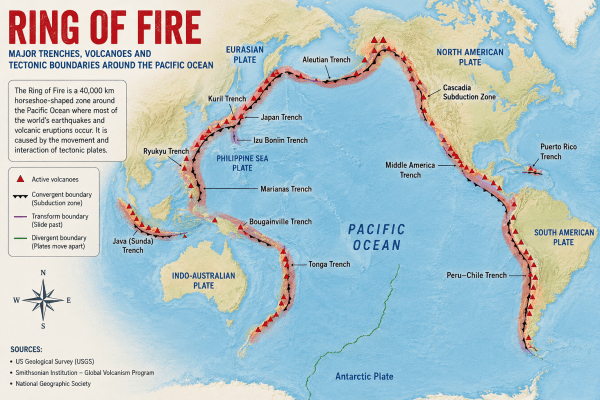
One of the most important processes is subduction. At a subduction zone, a denser oceanic plate is forced beneath another plate. Stress can accumulate along the boundary and eventually be released as a powerful earthquake.
Story continues below this ad
Subduction can also generate magma, which helps explain the large number of volcanoes found around the Pacific.
The USGS describes the Ring of Fire as a zone of frequent earthquakes and volcanic eruptions associated with volcanic arcs and deep ocean trenches around the Pacific Basin.
.
World · Science · Explainer
Does the Ring of Fire really form a ring?
The name is useful shorthand for the belt of quakes and volcanoes around the Pacific — but it isn’t one continuous structure.
.
PACIFIC
plate meets many others
.
.
.
.
.Subduction zones
.Transform (e.g. San Andreas)
.Gaps = not continuous
The gaps are the point: it’s a series of connected boundaries, not a single closed ring. Schematic, not to scale.
Does it form a single ring?
Not exactly.
It describes a broad zone of seismic and volcanic activity around the Pacific — not one continuous geological structure.
It’s better understood as a series of connected tectonic boundaries, involving different plates and different types of faults.
Some sections are dominated by subduction; others involve plates sliding horizontally past each other.
California’s San Andreas Fault is a transform boundary — plates moving sideways relative to each other.
The USGS describes it as where the Pacific Plate meets many surrounding tectonic plates.
Is the whole belt suddenly more active?
No clear evidence.
81%
of the world’s largest earthquakes occur along the circum-Pacific belt (USGS) — but that doesn’t mean one section’s quakes are linked to another’s.
Several big quakes in a short window can look connected because they sit on the same broad belt.
But scientists don’t treat it as one fault system that switches on and off.
Recent quakes in Indonesia, Colombia and elsewhere are separate tectonic events — unless seismology establishes a direct link.
A region built around seismic risk
Not if, but how ready.
For these countries the question isn’t whether earthquakes will strike, but how prepared communities are when they do.
Indonesia’s recent Flores earthquake triggered landslides, blocked roads and cut communications — isolating remote communities and slowing rescue even after the tsunami warning lifted.
The same belt holds some of the world’s largest population centres and most active volcanoes.
It’s less a single unfolding disaster than a permanent hazard zone — an unavoidable consequence of moving tectonic plates.
Source: US Geological Survey (USGS). Explainer — schematic diagram not to geographic scale.
.
(With inputs from National Geographic, AP, Reuters)
